A recent wave of avian influenza outbreaks has been reported as birds migrate across North America, affecting not only wild birds but also commercial and domestic flocks. In light of these bird flu outbreaks, it is necessary that members of the industry keep up-to-date to ensure the health of their birds and safety of their poultry products.
To help poultry growers and producers monitor these outbreaks of avian influenza, WATTAgNet has created an interactive map tracking confirmed cases in North America in 2015: https://batchgeo.com/map/2015-avian-influenza-outbreaks.
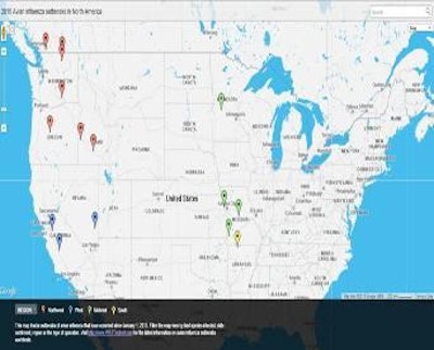
Since being confirmed in the state of Washington in December 2014, avian influenza cases have spread throughout the Pacific Northwest into Canada, as well as into the Midwestern and Southern states. To track the locations of these cases, the avian influenza map allows users to filter by region. Users can also filter by bird species, type of operation affected, avian influenza strain and date confirmed. Clicking on each marker on the map displays key information for the bird flu incident with a link to learn even more about that specific case.
The map is updated as soon as possible once a new confirmed case is reported.


